Barrientos Island, Aitcho Group, ANTARCTICA: 360 Degrees Panoramic Picture
Barrientos Island, Aitcho Group, ANTARCTICA: 360 Degrees Panoramic Picture
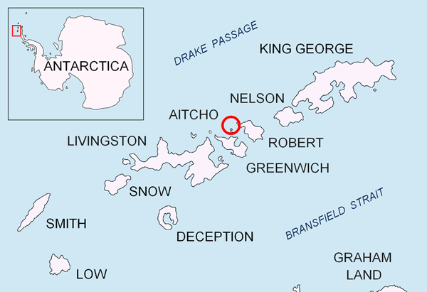
 Map of Barrientos Island, Aitcho Group, ANTARCTICA: Sources – Wikipedia.org
This is another great picture from the Antarctica trip from 4x4WorldExplorer.com. Let me tell you more about this 4x4WorldExplorer.com. The 4x4WorldExplorer.com are veterans in organising long distance 4×4 expedition-styled adventure vacations. Since 1992 they have covered the continents of Asia, Europe, Middle East, Africa and the Americas. In January, I joined them for a trip of my lifetime, venturing Patagonia of Argentina. The whole trip was inclusive of 11 days cruise of Antarctica. However, due to my busy schedule, sadly I didn’t make it to the Antarctica. I was in Ushuaia and left Argentina early.
Click image for larger image.
Barrientos Island is one of the islands they stopped at the Aitcho group of islands in Antarctica. Barriendtos is an almost ice-island one the west side of the English Strait in the South Shetland Islands, Antarctica. The ara is first reported visited by early 19th century sealers. Barrientos Island is now a popular tourist site frequented by Antarctic cruise ships – Wikipedia.org
Click image for larger image.
The group went on with Clippers Adventurer cruise. They are one of the better Antarctic cruises. The pictures are taken if not mistaken with an iPhone. The panoramic view of the photo is amazing!
Look out for more upcoming adventures from 4x4WorldExplorer.com at www.4x4WorldExplorer.com. They will be traveling from South Africa to Egypt in 2011! Follow them for the greatest adventure of your life!


0 thoughts on “Barrientos Island, Aitcho Group, ANTARCTICA: 360 Degrees Panoramic Picture”